Log in
All resources
Create a design
2,977 Free Artworks of City Map
bibliothèque nationale de france
maps of paris from bibliothèque nationale de france
atlas map
turgot map of paris, bibliothèque nationale de france
baroque
maps by willem and johannes blaeu
beschreibung der städt der welt - braun & hogenberg - btv1b52512111k
classicism
media from the national library of finland
plankarta öfver helsingfors stad 1916
pamir mountains
hindu kush
pamir mountains
hindu kush
maps of paris from bibliothèque nationale de france
maps of paris by braun & hogenberg
beschreibung der städt der welt - braun & hogenberg - btv1b52512111k
maps of wissembourg by braun & hogenberg
landais & oberthur
maps from gallica
beschreibung der städt der welt - braun & hogenberg - btv1b52512111k
maps of nuremberg by braun & hogenberg
beschreibung der städt der welt - braun & hogenberg - btv1b52512111k
maps of wittenberg by braun & hogenberg
maps of paris from the david rumsey historical map collection
turgot map of paris, david rumsey historical map collection
maps of valenciennes city walls
old maps of valenciennes
topographia alsatiae (merian)
baroque
maps of cusco by braun & hogenberg
eran laor cartographic collection
topographia alsatiae (merian)
baroque
watercolor drawings by johannes vingboons
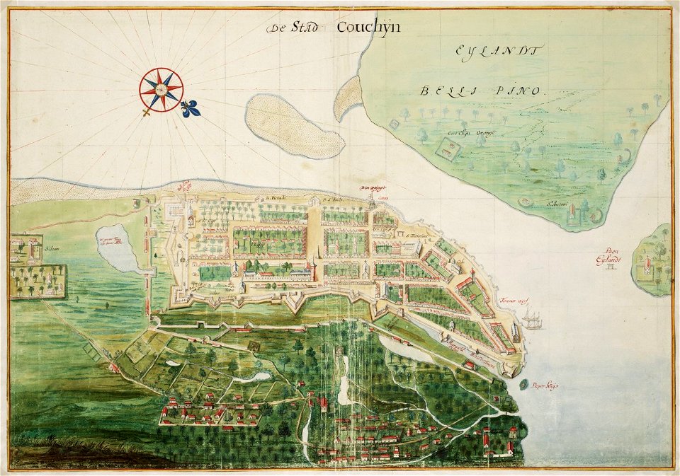
old maps of kochi, kerala
bird's eye view maps of connecticut
jewett city, connecticut
turgot map of paris, bibliothèque nationale de france
maps of paris from bibliothèque nationale de france
turgot map of paris, bibliothèque nationale de france
maps of paris from bibliothèque nationale de france
turgot map of paris, bibliothèque nationale de france
maps of paris from bibliothèque nationale de france
turgot map of paris, bibliothèque nationale de france
maps of paris from bibliothèque nationale de france
turgot map of paris, bibliothèque nationale de france
maps of paris from bibliothèque nationale de france
turgot map of paris, bibliothèque nationale de france
maps of paris from bibliothèque nationale de france
turgot map of paris, bibliothèque nationale de france
maps of paris from bibliothèque nationale de france
turgot map of paris, bibliothèque nationale de france
maps of paris from bibliothèque nationale de france
turgot map of paris, bibliothèque nationale de france
maps of paris from bibliothèque nationale de france
turgot map of paris, bibliothèque nationale de france
maps of paris from bibliothèque nationale de france
turgot map of paris, bibliothèque nationale de france
maps of paris from bibliothèque nationale de france
turgot map of paris, bibliothèque nationale de france
maps of paris from bibliothèque nationale de france
turgot map of paris, bibliothèque nationale de france
maps of paris from bibliothèque nationale de france
turgot map of paris, bibliothèque nationale de france
maps of paris from bibliothèque nationale de france
turgot map of paris, bibliothèque nationale de france
maps of paris from bibliothèque nationale de france
turgot map of paris, bibliothèque nationale de france
maps of paris from bibliothèque nationale de france
turgot map of paris, bibliothèque nationale de france
maps of paris from bibliothèque nationale de france
turgot map of paris, bibliothèque nationale de france
maps of paris from bibliothèque nationale de france
turgot map of paris, bibliothèque nationale de france
maps of paris from bibliothèque nationale de france
turgot map of paris, bibliothèque nationale de france
maps of paris from bibliothèque nationale de france
old maps of milan
domenico aspari
prints published by jacob van meurs in the rijksmuseum amsterdam
prints by jacob van meurs in the rijksmuseum amsterdam
maps of cambrai city walls
old maps of cambrai
beschreibung der städt der welt - braun & hogenberg - btv1b52512111k
maps of mons (hainaut) by braun & hogenberg
media from the national library of finland
classicism
media from the national library of finland
classicism
hamburgische elbkarte von melchior lorichs
parts of old maps of hamburg
topographia westphaliae (merian)
baroque
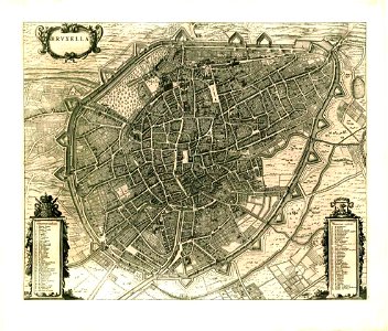
maps of brussels city walls
old maps of brussels
18th-century maps of antwerp
maps of antwerp city walls
maps by willem and johannes blaeu
old maps of breda, netherlands
plan de la ville et faubourg de paris, divisé en ses 48 sections by mondhare & jean
maps of paris from bibliothèque nationale de france
algeria in the 1880s
old maps of algeria
map of maastricht by willem and johannes blaeu (1649)
jekerkwartier (maastricht)
maps by willem and johannes blaeu
1651 in germany
old maps of ulm
philipp renlin
maps from the earth and its inhabitants, vol. xi
africa in the 1890s
jan karel donatus van beecq
hernán cortés
old maps of emden
baroque
maps in the british museum
old maps of dunkerque
old maps of algiers
maps from gallica
illustrations from découverte de la terre
19th-century maps of cities
sixth map of paris from traité de la police
maps of paris from paris musées
maps of ingolstadt by braun & hogenberg
maps of munich by braun & hogenberg
media from the national library of finland
classicism
media from the national library of finland
classicism
civitates orbis terrarum. de praecipuis totius universi urbibus. liber secundus
maps of neuss by braun & hogenberg
civitates orbis terrarum. de praecipuis totius universi urbibus. liber secundus
maps of kleve by braun & hogenberg
civitates orbis terrarum. de praecipuis totius universi urbibus. liber secundus
maps of wissembourg by braun & hogenberg
maps of paris from bibliothèque nationale de france
proletarian literature
old maps of the amazon river
1700s maps of brazil
maps of groningen by braun & hogenberg
history of groningen (city)
atlas vingboons
1665
18th-century maps of antwerp
maps of antwerp city walls
colonial history of the united states
old maps of new york (state)
landais & oberthur
maps from gallica
prato in the 20th century
maps of prato
maps of paris from the david rumsey historical map collection
maps of paris by caspar merian
hamburgische elbkarte von melchior lorichs
parts of old maps of hamburg
prints of cartouches in the rijksmuseum amsterdam
maps in the rijksmuseum amsterdam
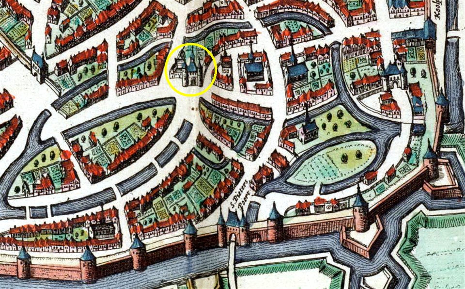
herenpoort (leiden)
old maps of leiden
hakodate city central library
maps by takeshiro matsuura
eran laor cartographic collection
cornelis de bruyn
map of maastricht by willem and johannes blaeu (1649)
first medieval city wall of maastricht
old maps of vermandois
maps of somme river
algiers in the 19th century
old maps of algiers
koninklijk oudheidkundig genootschap, amsterdam
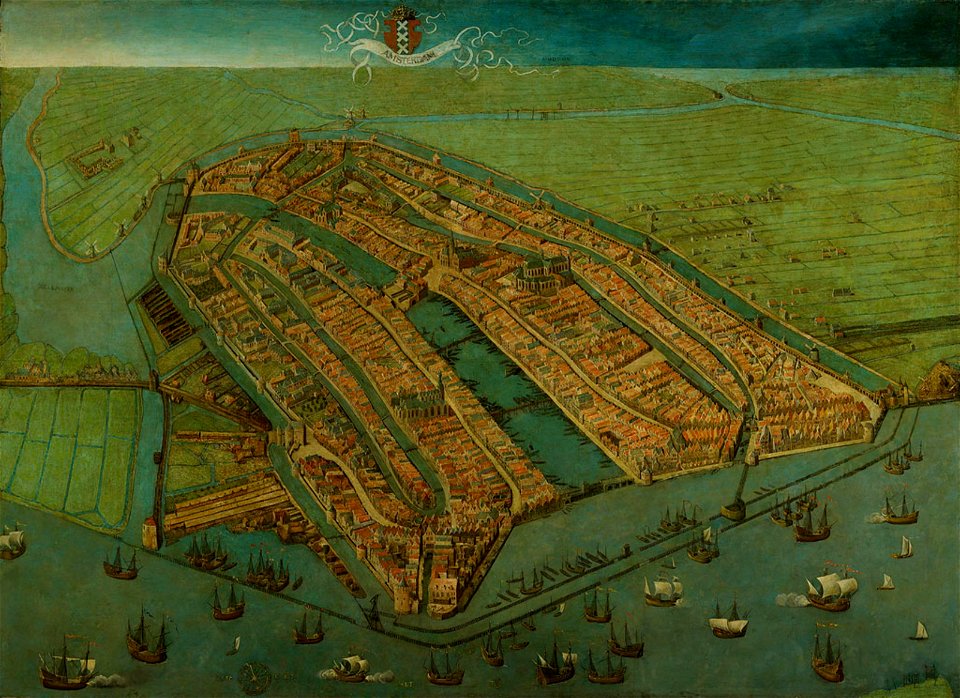
map of amsterdam, 1544
maps of paris from the university of wisconsin-milwaukee libraries
plan de roussel
1860 valentine map of new york city
george hayward
maps by willem and johannes blaeu
old maps of damme
maps of paris from bibliothèque nationale de france
fourth map of paris from traité de la police
maps by john cary
1799 maps
cityscapes of billings, montana
old maps of cities in montana
maps of paris by braun & hogenberg
georg braun
maps in the library of congress
1773 maps of the united states
dripps maps of manhattan published in 1867
neoclassicism
1801 maps of germany
maps by john cary
print room of the university of antwerp
plattegrond van antwerpen
coats of arms of cities in haute-marne
charles-guillaume étienne
anthonisz., cornelis - gezicht op amsterdam in vogelvlucht - amsterdam museum
amsterdam
maps of paris from bibliothèque nationale de france
maps of paris by jean lattré
maps of paris from bibliothèque nationale de france
16th-century maps of paris
old maps of cities in asturias
1777 maps of spain
eran laor cartographic collection
alexis-hubert jaillot
topographischer atlas der schweiz
old maps of fribourg
foire saint-germain on old maps
baroque
401 - 500 of 2,977
Next page
/ 30